C-Master generates output data that is compatible with these two popular programs.
The PETRA interface builds a *.LIC file from a strip log, allowing it to be directly imported into PETRA. The LIC file is built from the lithology log data in real time during log strip generation. Change the log, re-run your PETRA log strip and you’ll have new data ready to process! Lay the lithology logs alongside an e-log or other logging data to correlate the results between systems.
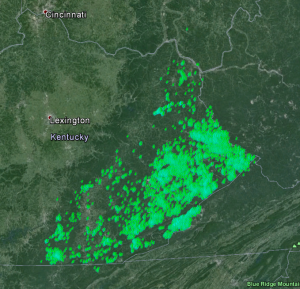
The Google Earth interface generates KML files from lithology logs, boundary files, or both. Display of these data is as simple as double-clicking the KML file and opening up Google Earth’s desktop application. Here is an example; 10,423 drill holes in Eastern Kentucky, selected by State Code and filtered by the State boundary lines. If you zoom in, you can select the individual drill holes and view your selected data at that data point.
In addition to displaying your logs in Google Earth, you can also display the log strip associated with that drill hole in Google Earth. To accomplish this, you create a JPG version of a log strip, and the log strip will be automatically attached to the push-pin associated with your log when the KML file is generated.
C-Master also generates CSV files directly from batches of logs, suitable for importation to a variety of processing programs. You choose the logs and the individual data you wish to export. Data can be saved as CSV or tab separated, or special character separated. It’s whatever you need to more efficiently pass data around.
C-Master can also ingest (import) CSV/Tab delimited data and create C-Master compatible logs that can be integrated into your system.
C-Master will also import C-Master files from other systems, retaining the basic information from each log during the importation processing.